|
|
The Channel Islands and the Great War
|
|
245 (Guernsey)
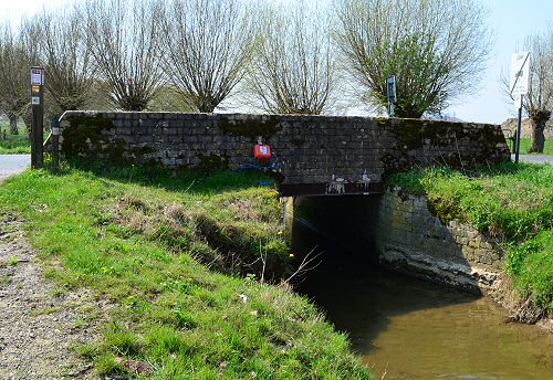
AT Coy Bridge in Belgium
|
|
In August 2017 we received some
information, files and photographs from Peter
Oldham who had spent some time researching the
origins of this insignificant looking bridge.
I was able to visit in April 2019 to take some
up to date photographs.
Peter wrote:
"You may be interested to
know that a small concrete bridge in Belgium ,
where Sgt Tostevin was awarded the MM and Sappers
La Serre*, Langlois and Rihoy were gassed building
it, still exists and is now in the process of
being listed as a historic monument for protection**.
The 245 ( Guernsey ) Army Troops Company cast
the deck, and the parapet walls a month later.
There is an inscription on the parapet by 245
AT, although there is still a query over the date.
Attached is a Belgian government
listing of the bridge, together with a book entry.
Further to this info it is now confirmed that
the bridge is Guernsey built. Confirmation was
needed because the Belgians, rightly, want preservation/listing
details to be accurate, and a recent battlefield
guide (Major and Mrs Holt) said it was American
and called it the"American Bridge" which
was then put out by the local tourist board. Holts
now accept the error, but there are many books
in circulation.
Also, war diary for 7th September recording the
gas shelling (which is where Sergeant Peter Tostevin
was later awarded the Military Medal) and that
for post-war, where four men died from carbon
monoxide.
There is some confusion over the inscribed
date on the bridge (7th August) when the first
work carried out was 7th September. Also, it is
a little weather-worn and I only realised the
significance of the G later. 245 (G) AT RE."
*Sapper La Serre was Sapper
Arthur Le Lerre and his name was transcribed
from the handwritten Company War Diary.
** This protection has been valid since 21/03/2018 |
Furthur research shows that there
were at least seven men killed or wounded at this
site:
|
|
Guernsey Evening Press 7th June
1919 – Smart Bridge Building, Men decorated
in the field.
245 (Guernsey) Coy. Army Troop R.E. Bridge Building
under shellfire.
The company were refitted and were moved to Ypres
and Poperinge area. A party of them was sent to
a place close to Dickebush to construct a heavy
bridge to enable the tanks to take part in an
advance. This work was completed under shell fire,
and two men were gassed.
Sergt. P. Tostevin***, who was in charge of the
party received the Military Medal. This was also
an immediate award.
Congratulations to the R.E. 245 (Guernsey) A.T.
Company from General Glubb. Chief
Engineer of 2nd Army.
|
***London Gazette (SIXTH SUPPLEMENT) Issue No. 31142
published on the 21 January 1919. Page 10 of 56 (Left
hand pane under his original RE number not his Later
WR number)
|
The bridge is sited in a very
busy agricultural area and heavily used by by
large farm machinery. A tribute to the quality
of its construction and to the Guernseymen who
built it 100 years ago
|
|
|
|
|
April 2019
|
April 2019
|

This has been designated as an established
architectural heritage Concrete Bridge Kemmelbeek
This statement has been valid since 28/11/2013
|

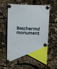
This has been designated as a
protected monument British bridge from the First
World War
This protection has been valid since 21/03/2018
|
|
British bridge over
the Kemmelbeek
Translated from the The Property
Heritage Agency of Flanders
|
Description
Bridge over the Kemmelbeek, on the border between
the municipality of Heuvelland and Ypres, along
the Vierstraat in Kemmel (Heuvelland) and the
Hallebaststraat in Dikkebus (Ypres). The bridge,
called Bardenbrug on pre-war maps, is located
southeast of the hamlet of Hallebast, northwest
of the hamlet of Vierstraat, southwest of Dikkebusvijver
where the Kemmelbeek flows. 500 meters southeast
of this bridge are the British military cemeteries
Klein Vierstraat British Cemetery and Kemmel No
1 French Cemetery .
Historical overview
Concrete bridge from the First World War, erected
in two phases by the British genius in September
- October 1918. Inscriptions can be found on the
bridge, which can probably be identified as follows:
"245 - G [...] - ATCy (?) - RE - 7 Aug. 1918"
. In full this becomes: "245th (Guernsey)
Army Troop Company Royal Engineers August 7, 1918"
. Judging from the war diary of the 245th (Guernsey)
Army Troop Company , this genius unit built this
bridge between September 4 and 7, 1918 along the
Vierstraat - Hallebast road, across Kemmelbeek.
The bridge was initially intended as a tank bridge,
in preparation for the Allied Liberation Offensive,
which was to start on 28 September 1918.
The circumstances in which the construction
of the bridge took place were not evident. The
Allies, more specifically American and British
troops, had tried unsuccessfully in the context
of the Relief Battle (August 18 - September 6,
1918) to conquer the German front line, the so-called
Vierstraete Ridge , against a high toll of human
casualties. The area around the bridge was therefore
heavily shot at by German artillery between 4
and 7 September. The 245th (Guernsey) Army Troop
Companyduring these days, despite these artillery
bombardments, worked continuously in three shifts
on the bridge. Two men were hit by a gas attack
during the construction of this bridge. To accomplish
this difficult assignment under infernal war conditions,
Peter Tostevin, who led the construction, received
a Military Medal together with his company .
Once the region was liberated, more
specifically from October 11, 1918, the same engineering
unit worked on the bridge a second time and buttresses
and parapets were added. Inscriptions were left
during this phase that refer to the builders.
Strangely enough, the bridge was marked “August
7, 1918,” while the first phase of building
the bridge was completed on September 7, 1918,
according to the war diary. until the award of
the Military Medal to Peter Tostevin. It seems
that there was a mistake when applying the date.
The bridge is largely constructed
with British prefabricated concrete bricks. More
specifically, it concerns British concrete bricks,
which were manufactured in the summer of 1918
in a workshop in Arques near Saint-Omer (France)
for the British 2nd Army . These concrete bricks,
often in combination with prefabricated concrete
beams, were mainly used for British bunker construction.
The concrete bricks and beams were provided with
round openings, into which rods could be placed
to anchor the bricks and beams. The slots on top
and bottom made it possible to place irons horizontally
between the rows.
Description
Bridge over the Kemmelbeek, with ramparts made
of concrete blocks on either side. Under both
parapets a steel beam with an I-profile is visible,
which spans the Kemmelbeek. The abutments terminate
on both sides in wing walls. On the southwestern
side, and probably originally also on other sides,
the wing wall was expanded into a buttress.
The wing walls / buttresses are,
as far as visible, largely constructed on the
basis of prefabricated concrete bricks. The lower
part of the abutments and of the wing walls are,
as far as visible, made of brick.
On the north-east side and south-west
side a construction seam is visible between the
wing wall / buttress and the bridge. A cement
layer has been applied at the top of the buttress
on the southwestern side.
The parapets are erected with concrete
bricks, arranged in ten rows. A layer of cement
has been applied to the top of the southern parapet
and to the sides of the parapets. Inscriptions
have been made on the southwestern side, which
can probably be deciphered as follows: "245
- G [...] - ATCy - RE - 7 Aug 1918" .
|
The
Property Heritage Agency of Flanders - current web
listing with map

Kew, The National Archives: 245th
Army Trps Coy RE Apr 1918-Apr 1919. War Diary ,
WO_95_329_7.
Captured German Trench and Operations Maps from
the National Archives [CD-ROM published by The Naval
& Military Press], Stellungskarte N ° X
Wytschaetebogen , 2/5/1917.
The Imperial War Museum Trench Map Archive on CD-ROM
(CD-ROM published by The Naval & Military Press
in association with the Imperial War Museum): British
military map 28 SW I, Ed 3b, Kemmel , 6/7/1918.
Topographical map of Belgium, Revision third edition,
Military Cartographic Institute, scale 1: 20,000,
map 28/5, 1911.
Sn 1952: History of the Corps of Royal Engineers.
Volume V. The Home Front, France, Flanders and Italy
in the First World War , Chatham.
ASTON J. & DUGGAN LM 1936: The history of the
12th (Bermondsey) Battalion East Surrey Regiment
, Finsbury.
DECOODT H. 2017: British bridge from the First World
War in Heuvelland (Kemmel) and Ypres (Dikkebus)
. Unpublished protection file, Immovable Heritage
Agency.
EDMONDS J. sd: Official History of the War. Military
Operations. France and Belgium 1918 , Volume II
Maps, London.
O'RYAN 1921: The Story of the 27th Division , volume
I, New York.
OLDHAM P. 2014: Armageddon's Walls. British Pill
Boxes 1914-1918 , Barnsley.
VENZON AC & MILES PL (ed.) 1995, The United
States in the First World War. An Encyclopedia ,
New York & London.
WILLIAMS D. 2015: British Second Army and Coalition
Warfare in Flanders in the Hundred Days, 1918 ,
University of Birmingham, unpublished doctoral thesis.
YOCKELSON MA 2008: Borrowed Soldiers. Americans
under British Command, 1918 , Norman.
Information provided by Franky Bostyn (13/5/2013).
Information provided by Peter Oldham (19/9/2012,
23/5/2013, 15/6/2013, 21/8/2017).
The Channel Islands Great War Study Group |
© 2019 Roger Frisby
|
Adapted from information supplied
by Peter Oldham with additions and photographs by Roger Frisby
(April 2019)
|
|